Properties Geological Setting &
Mineralization Styles
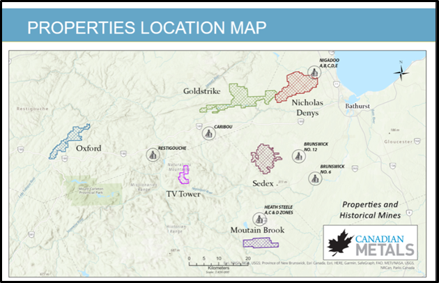
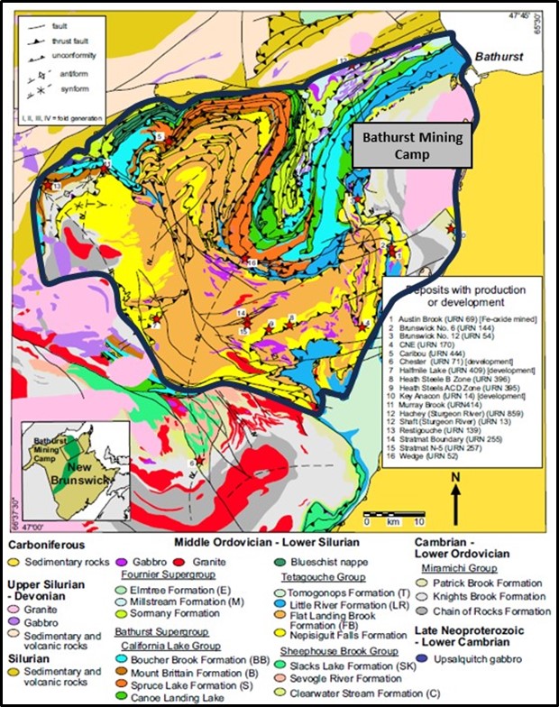
Canadian Metals Inc. properties are located in two very different geological environments, TV Tower, Sedex and Mountain Brook properties are located within the Bathurst Mining Camp (BMC) with typical Volcanic Massive Sulphide (VMS) type deposits. The Bathurst Mining Camp (BMC) was in operation between 1957 and 2013 and produced a total of approximately 179 Mt, with an average grade of 3.12% Pb, 7.91% Zn, 0.47% Cu, and 93.9 g/t Ag from 12 deposits (see Figures 1&3).
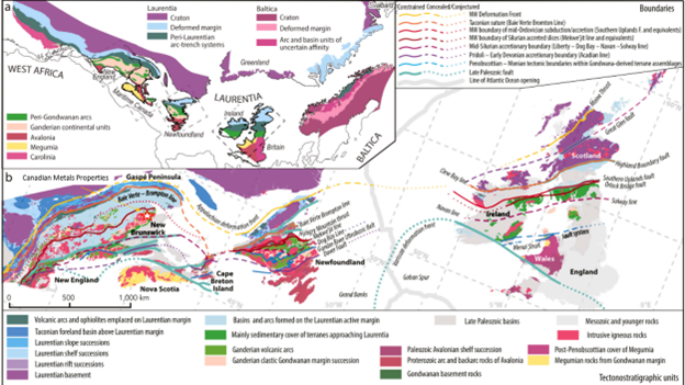
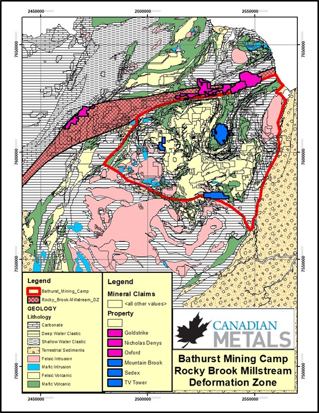
However, Oxford, Goldstrike and Nicholas Denys properties are located along a major deformation zone related to the Taconic Orogeny and Iapetus Suture, caused by the collision of ancient land masses at approximately 440 million years ago. The deformation zone consists of a series of anastomosing shears and faults that can be traced from Ireland to Newfoundland, New Brunswick to South Carolina and host major gold deposits along North Americas Atlantic coast (see Figures 1, 2 & 4). During the deformation phase the rheology and lithology of the rock units created zones of increased permeability favouring the precipitation of silica, sulfides and gold. Canadian Metals’ three properties cover an approximately 41-kilometre section of this fertile deformation zone. In addition, the Nicholas Denys property hosts a Quartz Monzonite-Granodiorite pluton that has potential for skarn and porphyry type deposits.
NICHOLAS DENYS PROJECT
- Property is 100% owned.
- Located near Bathurst, comprises 356 units held in two contiguous mineral claims encompassing 7,591 ha (75.9 km2).
- Is divided in two mineral claims named: Ann’s Creek and Beresford Copper.
- Advanced project containing high-grade silver polymetallic mineralization, with both 43-101 compliant and historical* (non-43-101 Compliant) resources located next to the city of Bathurst, New Brunswick, north of highway 180.
- Over 100 known occurrences mostly under-explored, and many non-explored anomalies.
- The property is over 15 km long covering a major regional structure – the Rocky Brook – Millstream Deformation Zone (RBMDZ).
- Purchased in July 2021 in an all-share deal valued at about C$5.5M.
- Nicholas Denys Granodiorite Pluton: Limited drilling for porphyry copper-gold-moly style mineralization has returned best result of 209.1m with 319ppm Cu plus 627ppm Mo.
- Beresford Copper Deposit: A skarn type deposit located within the contact metamorphic aureole of the Nicholas-Denys granodiorite intrusion and along the RBMDZ. Both mineralized zones are hosted by limestones of the Silurian La Vieille Formation belonging to the Chaleurs Group. Mineralization consists of magnetite-chalcopyrite-rich lenses that occur within a calc-silicate skarn zone. Has a historical* (non NI43-101 compliant) resource of 411,800t with 1.29% Cu (Canadian Mines Handbook 1972-73, PG.226).
- Pine Tree Deposit: Historical* (non NI43-101 compliant) 95,800 Tonnes with 2.82% Pb, 3.4% Zn, plus 80.57g/t Ag (JL Davies et al. (1969) GSC Paper 67-49, Pg.20, and Mackenzie 1957).
- Half Mile Deposit:
– Vein-1 Historical* (non-43-101 compliant) 15,600 Tonnes: 120m long by 1.3m wide to a depth of 30m, at 4.47% Pb, 3.9% Zn, 85.71 G/t Ag.
– Vein-2 Historical* (non-43-101 compliant) 5,700 Tonnes: 30m long by 1.9m wide to a depth of 30m, at 2.24% Pb, 3.27% Zn plus 115.2g/t Ag (JL Davies et al. (1969) GSC Paper 67-49, Pg.20, and Mackenzie 1957). - Hachey Deposit: In 2008, Puma reported a NI 43-101 resource estimate for the Hachey deposit at a 1% Zn Eq cut off, the deposit is estimated to contain an indicated resource of 364,312 tonnes grading 1.43% Zn, 0.7% Pb, 95g/t Ag and 0.53g/t Au; and an Inferred resource or 442,703 tonnes grading 1.06% Zn, 0.66% Pb, 55g/t Ag and 0.31g/t Au. (Innovexplo,Turcotte B., Peletier C., 2008-02-18 for Puma Exploration).
- Shaft Deposit: Mineralization occurs along the South Branch of the RBMDZ. The mineralization is represented by zones of pyrrhotite, pyrite, sphalerite and galena veins and is structurally controlled. Historical* (non-NI 43-101 compliant) Indicated Resource 74,800 Tonnes @ 1.17% Pb, 4.58% Zn, 124.46g/t Ag to a depth of 76.2m and Inferred Resource 238,100 Tonnes @ 28% Pb, 3.3% Zn, 111.77g/t Ag to a depth of 152.4m, (JL Davies et al. (1969) GSC Paper 67-49, Pg.20, and Mackenzie 1957).
- Millstream Henry Deposit: Mineralization consists of massive to disseminated sulphides in or near carbonate-rich veins, fractures and lenses that cut the sheared and brecciated graphitic schist and argillite. Historical* (non NI 43-101 compliant) 71,7000 Tonnes grading 2.23% Pb, 1.57% Zn, 163.2 g/t Ag, and 1.06 g/t Au. (Work Report 471694 N. American Rare Metals, 1977). In 2012 Puma retested this occurrence with best intersection returning a 13-meter intersection in hole FH12-05 grading 0.90 g/t Au, 162 g/t Ag, 1.10% Pb and 1.38% Zn and a 3-meter intersection in hole FH12-10 grading 2.30 g/t Au, 187 g/t Ag, 1.46% Pb and 1.51 % Zn.
- More than one hundred mineral occurrences reported on the property, including Zn-Pb-Ag-Au, Cu, Au, Fe, Fe-Cu, Mo and Mo-Cu.
- Multiple mineralization styles including hydrothermal systems associated with the emplacement of the stock and feldspar porphyry dykes that intrude the host rock.
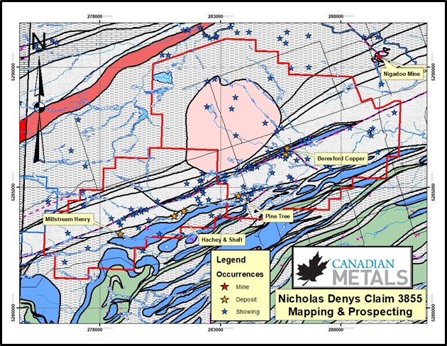
Figure 5: Nicholas Denys Property showing historic deposits and prospects
GOLDSTRIKE PROPERTY
- Property comprises 6 contiguous mineral claims owned 100% by Canadian Metals Inc. encompassing 7,924 ha.
- Contiguous to CME’s Nicholas Denys project to the east and road accessible.
- The Property has shown visible gold and new mineralized zones in 2022 trenching program.
LG Gold Zone Area
The LG gold zone refers to the series of gold occurrences related to the Benjamine Rhyolite (Clarinda, Clarinda NE Extension, Alyssa, and Arleau). See Figure-6 below. As described above they were formed by the interaction of the Rocky Brook-Millstream Deformation Zone with competent rock units undergoing brittle ductile deformation thus creating zones of increased permeability where hydrothermal fluids favoured the deposition of silica, sulfides and gold.
These occurrences are in a similar geological and structural setting to Puma’s Lynx, Cougar, Jaguar and Panthera, high grade gold zones, including Stratabound’s, and Gold Terra’s high grade gold zones, which are all hosted within similar felsic volcanic rock units within the Rocky Brook-Millstream Deformation Zone.
- Clarinda NE Extension: Discovered in 2019 by Tim Lavoie where a grab sample from an exploration trench returned an assay of 455 g/t Au from a quartz vein. This was followed up in 2022 with a more extensive trenching and channel sampling program. A system of auriferous quartz veins was exposed over a thickness of more than 20m where channel samples returned grades up to 48 g/t Au over 1.0m from quartz veins and altered rhyolite.
- Clarinda Showing: Discovered by Lorenzo Noël in 1997 while prospecting along a new lumber road noted gold bearing gossanous sediments. More recent follow-up work included 15 DDH which returned: 3.1g/t Au over 5.5m, 0.43g/t Au over 11.5m, 0.674g/t Au over 17.1m and shorter intervals of up to 8g/t Au and 15.8g/t Au in outcrop. Largely underexplored.
- Alyssa Showing: Discovered by Tim Lavoie in 2019 while prospecting along a new lumber road returned 28 g/t Au, and 1.79 g/t Au from altered and veined rhyolite. No follow-up done to date.
- Arleau Showing: Discovered by Lorenzo Noël in 1999 (WR-475222) with best grab samples results returning 27.5, 19.0 and 3.76 g/t Au. In 2019 Tim Lavoie prospected and trenched the area with best results including 4 g/t Au, 0.694 g/t Au, 0.453 g/t Au. He repeated result from the historical trenches and while prospecting found an area 150m to the southwest where grab samples from boulders returned 10.4 g/t Au.
The LG gold zone is considered to be a high priority target to make new discoveries and expand the known occurrences.
Millstream Area
- Millstream West Gold-A: Discovered in 1987 by Delbert Stewart when he found an angular, locally derived boulder of quartz-ankerite (± 5% arsenopyrite, pyrite) that returned of 6.2 g/t Au. The gold occurs in fine felty to massive arsenopyrite associated with quartz-carbonate veins and pervasive alteration in Silurian – Free Grant Formation sedimentary rocks adjacent to and within narrow, fine gabbro dykes. In 1988 sixteen holes were drilled along the 366m strike length of the dyke. Several holes intersected significant gold mineralization in altered siltstone and diabase contacts, the best intersection being 9.95 g/t Au over 1.5 m. There is great potential to add value as this showing is within the RBMDZ and the gabbro rock units underwent brittle-ductile deformation similar to the rhyolite described above.
- Millstream West Gold-B: During a drilling program to test geochemical anomalies Acadia Mineral Ventures intersected 28.9 g/t Au over 0.15 m and 30.8 g/t Au over 0.11m for a weighted average of 3.39 g/t Au over 2.47m in Drill Hole SM88-17 within and at the contact between sediments and a gabbro dike.
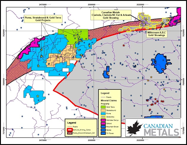
Figure 6: Goldstrike Property – regional map showing historical prospects and new showings.
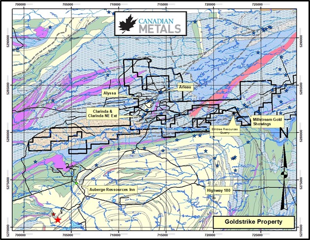
Figure 7: Goldstrike Property –map showing historical prospects and new showings.
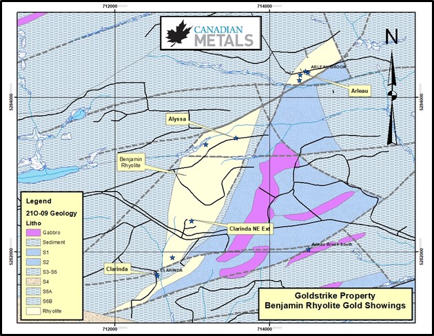
Figure 8: Gold Showings associated with the Benjamine Rhyolite.
OXFORD PROPERTY
- The Property comprises 169 units held in one mineral claim encompassing 3,667 ha (36.7 km2).
- Adjacent to Puma’s recent high grade gold discoveries.
- Host felsic volcanic rocks with VMS style zinc-lead–silver type mineralization.
- Mineralization is in the form of disseminated sphalerite and galena and locally up to 10% pyrite in chloritized and silicified felsic volcanic rocks grading up to 3 g/t Au, 15 g/t Ag, 1.11% Zn and 0.48% Pb.
- Follow-up sampling in 2013 trench returned the highest grade reported to date 8.9% Zn and 5.16% Pb
- A shear zone favorable for gold mineralization
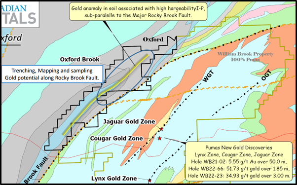
Figure 10: Oxford Property Geology and showings.
MOUNTAIN BROOK PROPERTY
- Property comprises a total of 139 claim units covering approximately 3,048 ha.
- The Mountain Brook Property is located only seven km south of the past-producing Heath Steele Mine (3.8Mt @ 2.9% Pb, 7.1% Zn, and 2.7Mt @ 1.2%Pb, 3.5%Zn) over similar geology.
- Mountain Brook is underexplored, yet exhibits key characteristics for economic VMS mineralization with little follow up on past discoveries.
- Felsic volcanic host rocks, dynamic structural deformation, and a known past-producing mine occur along same geological horizon.
- Major East/West structure runs across the property, bisecting folded felsic volcanics, and contiguous with the host rock to the past producing Heath Steele Mine.
- 2017 drilling intersected sulphide stringer mineralization (pyrrhotite / pyrite /chalcopyrite) and highly prospective units often found in a VMS feeder system. Highlights included MB82-01 (1.48% combined Pb, Zn, Cu) over 4.9m, MB83-04 (13.37 g/t Ag, 4.95% Pb, 4.6% Zn, 0.36% Cu) over 0.5m, and MB83-05 (19.89 g/t Ag, 1.42% Pb, 2.33% Zn, 0.09% Cu) over 1.9m.
- In addition, the Tomogonops-Tozer and Pringle Brook Faults that crosscuts the sediments and felsic volcanics may be a structurally favorable areas to prospect for Gold.
The geological unit comprises quartz-feldspar crystal tuff and mafic volcanic rocks of the Tetagouche group. Zn, Pb, Cu and Ag mineralization is disseminated along the contact of the mafic and felsic rock and it is closely associated with magnetite and siderite mineralization.
- Mountain Brook’s best drill intersections include results up to 4.6 % Zn, 4.9 % Pb and 13.37 g/t Ag.
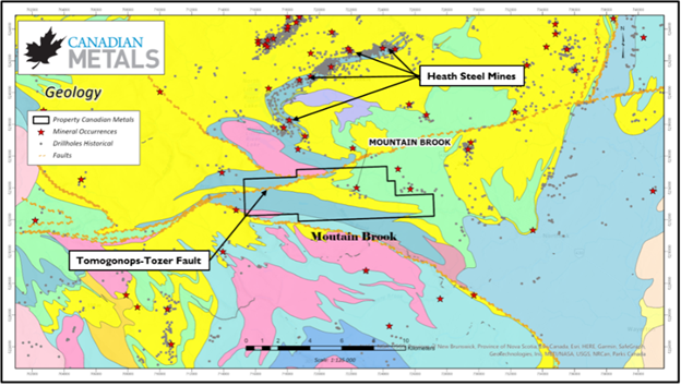
Figure 11: Mountain Brook Geology and showings.
SEDEX PROPERTY
- Property comprises a total of 249 claim units covering approximately 5,434 ha.
- Located 10 km west of the Brunswick #12 mine which during its 49-year lifetime (1964–2013), produced 136,643,367 tonnes of ore grading 3.44% Pb, 8.74% Zn, 0.37% Cu, and 102.2 g/t Ag, making it one of the largest underground base-metal mines in the world.
- Very little past work has been done on the Sedex property.
- Proximal to:
- The past producing giant Brunswick No 12 mine
- The Canoe Landing Lake deposit located 5.0km southwest contains 20,380,00 tonnes inferred resource @ 0.64% Pb, 1.82% Zn, 0.56% Cu, 29.5 g/t Ag and 1.07 g/t Au and 3,456,800 tonnes indicated resources @ 0.65% Pb, 2.48% Zn, 0.65% Cu, 44 g/t Ag
- A local prospector reported a brecciated boulder containing 4.1 g/t Au.
- Noranda reported float containing 12,600 ppm Zn and 2,320 ppm Pb in the vicinity of a conductor.
- Slam Exploration trenched a quartz carbonate zone with assay results up to returned 1 g/t Au from a carbonate altered quartz vein zone within a basaltic unit coincident with a prominent magnetic anomaly.
- The stibnite (or antimony) occurrence (1.71% Sb) (antimony is on the US critical minerals list).
- A newly discovered cluster of chert boulders containing chalcopyrite and malachite along a 550-metre section of lumber road
- Soil Geochemical survey carried out in 2022 has identified a number of targets to follow-up
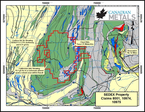
Figure 12: Sedex Property Geology & Showings
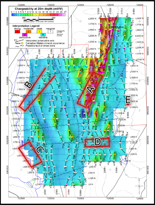
Figure 13: SEDEX property with IP Chargeability targets areas highlighted.
TV TOWER PROPERTY
- Property comprises a total of 53 claim units covering approximately 1,157 ha.
- Located 14 km south of the Trevali’s Caribou mine.
- Untested geophysical targets.
- Host rocks are similar to those at Brunswick Mine, with strongly altered dacitic to rhyolitic quartz feldspar crystal tuff, dark grey iron formation and massive sulphides.
- A report by Goldminds (2018) outlined 6 magnetic and EM anomalies that may be related to sulphide mineralization and remain untested
- The TV Tower Property hosts a Zn-Cu-Au massive sulphide style mineralization with newly defined targets that remains to be tested.
- The geological unit comprises dacitic to rhyolitic quartz-feldspar crystal tuff, dark grey iron formation and massive sulphides of the Tetagouche group.
- The property includes historical diamond drill results with intersections up to 5.15% Zn.
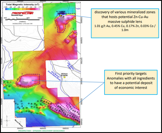
Figure 14: TV Tower Property with untested EM-magnetic anomalies identified.